Showing posts with label countries. Show all posts

Thursday, April 11, 2013

The origins of Liberia


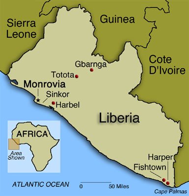
Liberia was one of the few African territories to remain free of the European imperialism after Berlin Conference. The name of the country means "land of the free" and it was founded by freed African slaves from the USA in 1820. The promoters of the resettlement of former slaves in Africa were the members of the American Colonization Society, an organization of white clergymen, abolitionists and slave owners. The name of its capital city, Monrovia, comes from James Monroe, the president of the USA in the early 1820s, when the resettlement of freed slaves started. 

File:Coat of arms of Liberia.svg
Liberia's coat of arms

Source: 
http://en.wikipedia.org/wiki/File:Coat_of_arms_of_Liberia.svg
In 1847 Liberia proclaimed its independence and became a republic. By the end of the American Civil War (1861-1865) around10,000 former slaves had settled down in Liberia. But the former slaves. But the former slaves took advantage of the situation to submit the indigenous Africans, black like them, but considered to be inferior. For example, the indigenous Africans who lived in Liberia were excluded from citizenship until 1904 and were also exploited by the Americo-Liberian elite, who monopolized political and economic power and restricted the indigenuos people´s rigth to vote.

The Liberian political system drew inspiration from the USA Constitution, but there was one only party, the True Whig Party, founded in 1869. This party held power until 1980, when a coup d' État removed them from power. A period of ethnic tensions and wars started:  two civil wars (1990-1996 and 1999-2003) with around 250,000 people killed. and one million refugees. In 2005 Ellen Johnson-Sirleaf was elected Africa's first female president and started the difficult reconstruction of the country. 

If you want to learn more about Liberia, here you have some extra links: 

http://www.bbc.co.uk/news/world-africa-13729504


Wednesday, October 26, 2011

Where is Cochinchina located?


This is the answer to Yolanda Rubio´s question: Cochinchina is a region that corresponds to the southern region of modern Vietnam (country coloured in green on the map above). In the 16th century the Portuguese gave the name Cauchichina to the region around the mouth of Mekong river. "Cauchi" could be derived from "Jiao zhi", the name the Chinese gave to Vietnam. The Portuguese added "China" to "Cauchi" to distinguish this place from another colony called "Cochin" they had in India. 

During the 2nd half of the 19th century Cochinchina became a French colony. Napoleon III decided to occupy this territory, with the help of the Spanish army, arrived from the Philippines. This is the origin of the Spanish expression "Eso está en la Conchinchina", meaning a very far and exotic place. 

Here you have some more information about Cochinchina: 

Monday, October 24, 2011

England, Great Britain and the United Kingdom

Today we have also commented on the correct way of naming a country throughout different historial periods. This was the case of England and Great Britain during the 17th and 18th centuries. Here you have a more detailed explanation:


- England existed as a unified kingdom from the 10th century to the beginning of the 18th century. 


The Kingdom of England in the 17h century:
J.Jansson, Atlas Novus (1646)


- The Kingdom of Great Britain existed from 1707 to 1801: it resulted from the unification of the kingdoms of Scotland and England (including Wales). 


Late 18th century hand coloured map of Great Britain (including Scotland and Wales)

- In 1801 the United Kingdom of Great Britain and Ireland was created, after the repression of the Irish Rebellion in 1798 and the suppression of the Irish autonomy.


- In 1922 the partition of Ireland resulted in the creation of the Irish Free State, which became the Republic of Ireland. Northern Ireland remained as a part of the United Kingdom. Since then, the official name of the country is United Kingdom of Great Britain and Northern Ireland. 

Map of the United Kingdom of Great Britain and Nothern Ireland, including regions of England


As you may remember, something similar happens with the different names our country has had: Spain wasn´t a unified kingdom until the beginning of the 18th century. This is why we use the name "Hispanic Monarchy" during most of the Modern Age. 

What was Prussia?


In blue colour, the Kingdom of Prussia at its greatest extent in 1876

Today some of you have asked about Prussia several times. Here you have a map where you will be able to learn its location in the past. Prussia was one of the most powerful German states and it had a very important role in the unification of Germany in the 19th century. We´ll study this in Unit 4. As a consequence of the two World Wars its former territories are distributed between Germany, Poland, Denmark, Russia and Lithuania at present. 

Here you have a map of Central Europe, where you can see which countries the former Prussian territories belong to now: 


If you want to learn more about this kingdom, visit the following link: 

Friday, March 11, 2011

Challenge number 11

This week´s challenge will be a "superquestion". The superquestion was the last part of a legendary TV contest, El tiempo es oro (Time is gold). This show was broadcasted between 1987 and 1992 and it was presented by Constantino Romero. In the final part of the show the contestant had to solve three linked questions. The answer to the first question allowed the contestant to go on with the second one and the answer to this one gave the clue to the third and definitive answer. The contestants could use several encyclopedias and dictionaries to solve the questions. You can do the same with your superquestion. As we´re starting a new unit next week, let´s review a little bit!

QUESTION 1

What body of water is this one? Where is it located (continent and country)?


QUESTION 2

One of the countries next to this body of water has five places considered as World Heritage Sites by the UNESCO. Which country is this? What´s its capital city? What of these World Heritage Sites is represented on the following image? Why was this city so important during the Middle Ages?


QUESTION 3

Explain what type of government the country where the body of water and the city of the pictures are located has.

And remember, don´t copy and paste! Write your own answers. You have time until Sunday, 22:00.