Showing posts with label maps. Show all posts

Thursday, November 3, 2016

Some more games to review physical geography

As usual, click on the images to play the games and review:

- This one is to review concepts related to geographic coordinates:


- Here you have another game to review the basic types of maps: 


- And the last one is to review all the concepts related to bodies of water:


Monday, September 30, 2013

Some maps to learn about international trade in the 17th century

Here you have some maps to study the evolution of trade during the Modern Era:

- This map includes the traditional trade routes controlled by Portugal and the Hispanic Monarchy (the spice route to Asia and the precious metals route to America) until the 17th century and also the triangular trade route. You can observe the main products exchanged in these routes: 


This is an interactive map about triangular that includes an oral explanation about the rise of cities as a consequence of trade. The map is focused in North America's trade. That's why it doesn't include the products exchanged between Europe and Africa. Click on the map to play the animation: 


Source: http://glencoe.com/sites/common_assets/socialstudies/in_motion_10/tav/TAV_039.swf

And this one also includes an oral explanation that you can follow reading the text below. Click on the image and later Play : 


And finally, here you have a report about the slave trade. The route the slaves followed was called Middle Passage: 

Thursday, April 11, 2013

The origins of Liberia


Liberia was one of the few African territories to remain free of the European imperialism after Berlin Conference. The name of the country means "land of the free" and it was founded by freed African slaves from the USA in 1820. The promoters of the resettlement of former slaves in Africa were the members of the American Colonization Society, an organization of white clergymen, abolitionists and slave owners. The name of its capital city, Monrovia, comes from James Monroe, the president of the USA in the early 1820s, when the resettlement of freed slaves started. 

File:Coat of arms of Liberia.svg
Liberia's coat of arms

Source: 
http://en.wikipedia.org/wiki/File:Coat_of_arms_of_Liberia.svg
In 1847 Liberia proclaimed its independence and became a republic. By the end of the American Civil War (1861-1865) around10,000 former slaves had settled down in Liberia. But the former slaves. But the former slaves took advantage of the situation to submit the indigenous Africans, black like them, but considered to be inferior. For example, the indigenous Africans who lived in Liberia were excluded from citizenship until 1904 and were also exploited by the Americo-Liberian elite, who monopolized political and economic power and restricted the indigenuos people´s rigth to vote.

The Liberian political system drew inspiration from the USA Constitution, but there was one only party, the True Whig Party, founded in 1869. This party held power until 1980, when a coup d' État removed them from power. A period of ethnic tensions and wars started:  two civil wars (1990-1996 and 1999-2003) with around 250,000 people killed. and one million refugees. In 2005 Ellen Johnson-Sirleaf was elected Africa's first female president and started the difficult reconstruction of the country. 

If you want to learn more about Liberia, here you have some extra links: 

http://www.bbc.co.uk/news/world-africa-13729504


Saturday, March 23, 2013

Germany from the unification to reunification

This is the answer to Juan´s question about the extension of Germany through history. Here you have some maps, where you can see the evolution of the country from 1871 to present day: 

THE GERMAN EMPIRE (SECOND REICH) FROM 1871 TO 1918

Imperial_Germany.jpg


GERMANY AFTER WORLD WAR 1 UNTIL HITLER´S ARRIVAL TO POWER (1918-1933)

The red colour indicates Germany´s territory during the Weimar Republic. In pink colour, the territories Germany lost as a consequence of the Treaty of Versailles (1919): 


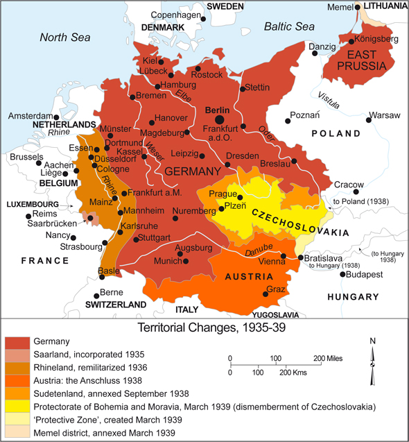
GERMANY DURING THE THIRD REICH (1933-1939)

The different colours indicate the territories seized by Hitler during this period. Most of them were the ones Germany had lost in the Versailles Treaty: 

Germany: Territorial Expansion (1935-1939)


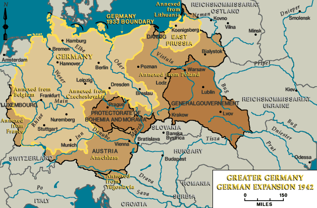
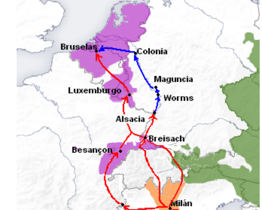
GERMAN EXPANSION DURING WW2

This map shows what the Nazis called the Greater Germany. It included all the territories annexed to Germany until 1942


GERMANY AFTER WORLD WAR 2 (1945-1948)

Germany was divided into four zones, occupied by the allies (USA, UK, France and the USSR). Berlin was also divided into four zones. In white, the territories given to Poland and the USSR in the East and the Saar Protectorate in the West (this last territory was administered by France until 1955. Later it reunified with the Federal Republic): 

File:Map-Germany-1945.svg


DIVISION OF GERMANY (1949-1991)

The disputes between the Western allies and the USSR led to the Berlin blockade in 1948. After this crisis, two States were created: the Federal Republic of Germany in the West and the German Democratic Republic in the East. Berlin continued to be divided into two zones. In 1961 a wall was built inside Berlin. It physically represented the division of the world into two opposed blocks during the Cold War: 


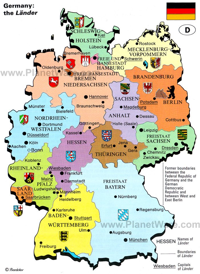
GERMANY  TODAY (1990 to present day)

After the fall of the Berlin Wall in November 1989, the reunification process of Germany started. Germany became officially an only State on the 3rd October 1990. 

This map shows Germany as it is today. You can observe the different Länder (federal States) which form it. The Länder are similar to the autobomous communities in Spain, but they have more power


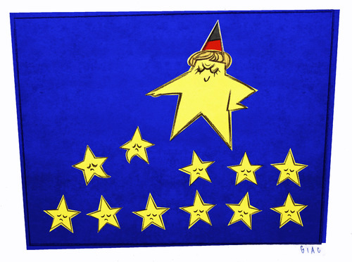
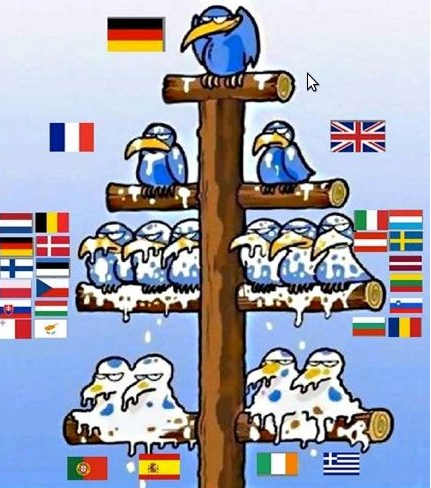
And finally, here you have some cartoons about something called German Europe. Experts say that things go better in Europe if there is a European Germany, rather than a German Europe. 


Tuesday, December 18, 2012

The Napoleonic wars in some maps

This is a collection of interactive maps related to the Napoleonic wars and the Napoleonic Empire. If you want to play them, click on the images. 

- This map comes from the BBC history website and it reproduces the Battle of Trafalgar, the sea battle that confronted the Hispano-French fleet with the British fleet commanded by Admiral Nelson: 


- This maps shows the extension of the Napoleonic Empire, including the allied States and its main enemies. It includes an animation of the Russian Campaign as well: 


- The following website explains all the details of the Russian Campaign (1812): 


- The last two links are two games about the Battle of Waterloo from the BBC and PBS websites. You can learn what happened, playing as Napoleon or the Duke of Wellington.


Yesterday I played the Battle of Waterloo as Napoleon and I won ;)

Thursday, October 25, 2012

Some interactive maps about triangular and slave trade


Here you have the links to some interactive maps I´ve found to learn more about international trade and slave trade: 

- A simplified map of triangular trade: 


- A more detailed map of triangular trade: 


- Triangular trade routes: this map includes an exercise to make sure that you´ve understood the products exchanged between every continent and the others: 


- African slave trade: on this map you can see where the black slaves came from mainly and what their main destinations in the Americas were: 


- Slave trade of the Seventeenth and Eighteenth Centuries: on this map you can see the territories in the Americas with the highest percentage of slaves: 


Sunday, October 14, 2012

The Spanish Road and the Dutch Lion

File:El Camino Español.PNG

The Spanish Road

As we studied last Wednesday, Charles I inherited a lot of territories in different parts of Europe. France continued to be the Hispanic Monarchy´s main enemy and it was difficult to keep all the territories connected. During Philip II´s rule a route was established to connect the Iberian Penindula (through the Aragonese ports of Valencia and Catalonia) with the North of Italy and the Low Countries. This route was known as the Spanish Road and it was used for trade, but also for military supply, especially during the Revolt of the Low Countries (1568-1648). This road was safer than the sea route which linked the Cantabrian ports of Castile with the Low Countries. 

If you want to learn more about this road, please click on the following link:


There is a classical history book about this road written by Geoffrey Parker in 1972: The Army of Flanders and the Spanish Road (1567-1659). Here you have a small review: 


The cover of The Army of Flanders and the Spanish Road (1567-1659) reproduces the Dutch Lion (Leo Belgicus), a map of the Low Countries drawn in the shape of a lion. This map was drawn for the first time in 1584, during the revolt of the Low Countries against Philip II´s authoritarianism. It symbolized the Dutch resistance against the king. The map included the territories of present Belgium and Hollans. Here you have more information about this strange map: 


The Dutch Lion

Sunday, June 17, 2012

WW2 animated maps

At Manuel´s request, here you have some links to learn about the different operation theatres of WW2: 

- This is a link to the presentation we saw last week in class. It was made by the Combat Studies Institute, a section of the United States Army Combined Arms Center, located in Fort Leavenworth (Kansas). On this link you can find the battle maps of the European and Pacific Theaters: 


- And this link belongs to the UK National Archives. Every animated map includes an audio explanation of the military operations on each theatre: 


Wednesday, October 26, 2011

Where is Cochinchina located?


This is the answer to Yolanda Rubio´s question: Cochinchina is a region that corresponds to the southern region of modern Vietnam (country coloured in green on the map above). In the 16th century the Portuguese gave the name Cauchichina to the region around the mouth of Mekong river. "Cauchi" could be derived from "Jiao zhi", the name the Chinese gave to Vietnam. The Portuguese added "China" to "Cauchi" to distinguish this place from another colony called "Cochin" they had in India. 

During the 2nd half of the 19th century Cochinchina became a French colony. Napoleon III decided to occupy this territory, with the help of the Spanish army, arrived from the Philippines. This is the origin of the Spanish expression "Eso está en la Conchinchina", meaning a very far and exotic place. 

Here you have some more information about Cochinchina: 

Monday, October 24, 2011

England, Great Britain and the United Kingdom

Today we have also commented on the correct way of naming a country throughout different historial periods. This was the case of England and Great Britain during the 17th and 18th centuries. Here you have a more detailed explanation:


- England existed as a unified kingdom from the 10th century to the beginning of the 18th century. 


The Kingdom of England in the 17h century:
J.Jansson, Atlas Novus (1646)


- The Kingdom of Great Britain existed from 1707 to 1801: it resulted from the unification of the kingdoms of Scotland and England (including Wales). 


Late 18th century hand coloured map of Great Britain (including Scotland and Wales)

- In 1801 the United Kingdom of Great Britain and Ireland was created, after the repression of the Irish Rebellion in 1798 and the suppression of the Irish autonomy.


- In 1922 the partition of Ireland resulted in the creation of the Irish Free State, which became the Republic of Ireland. Northern Ireland remained as a part of the United Kingdom. Since then, the official name of the country is United Kingdom of Great Britain and Northern Ireland. 

Map of the United Kingdom of Great Britain and Nothern Ireland, including regions of England


As you may remember, something similar happens with the different names our country has had: Spain wasn´t a unified kingdom until the beginning of the 18th century. This is why we use the name "Hispanic Monarchy" during most of the Modern Age. 

What was Prussia?


In blue colour, the Kingdom of Prussia at its greatest extent in 1876

Today some of you have asked about Prussia several times. Here you have a map where you will be able to learn its location in the past. Prussia was one of the most powerful German states and it had a very important role in the unification of Germany in the 19th century. We´ll study this in Unit 4. As a consequence of the two World Wars its former territories are distributed between Germany, Poland, Denmark, Russia and Lithuania at present. 

Here you have a map of Central Europe, where you can see which countries the former Prussian territories belong to now: 


If you want to learn more about this kingdom, visit the following link: 

Monday, August 1, 2011

Immappancy and the true size of continents


This is an interesting link provided by Kelly. It refers to the distorted image of reality commonly used maps offer. Mercator´s projection is the most used map projection in Europe. It enlarges the size of the Northern hemisphere and it makes us think that the places we live in are bigger than they are. On the following links you can learn more about a phenomenon called "immappancy" and check an example of the real size of Africa, a continent that could include such big countries as the USA, India and China and the most part of Europe altogether: 


Monday, February 28, 2011

The Atlas of the Real World

Today we have discovered a new way of representing different facts on world maps. It´s a project called The Atlas of the Real World. The authors represent the countries of the world not by their real size, but by their demographic importance on different subjects. Here you have some examples related to tourism. 

TOURIST ORIGINS


TOURIST DESTINATIONS


TOURISM EXPENDITURE


TOURISM PROFIT

This interesting book is called The Atlas of the Real World: Mapping the way we live, by Daniel Dorling, Mark Newnan and Anna Bartford and it was published byThames and Hudson. 

You can also find these maps on Worldmapper. Every map includes a short explanation and they are very useful to understand many world facts: 


Finally, here is the link to all the world maps about tourist: 

Friday, October 15, 2010

Thematic maps for the projects


Here you have an interesting link to get visual information for your projects. It´s the website of the CIESIN, the Center for International Earth Science Information Network, an institution of the Columbia University, one of the most prestigious universities of the U.S.A and worldwide. The CIESIN website hosts a collection of thematic maps that can be used to show different aspects of the Earth: climates, vegetation (biomes), landforms, population density... You can use these maps to prepare your presentations:

Monday, September 20, 2010

Some resources to study political geography of the continents


Hello everybody!

Here you have some interesting links where you can review the countries of the world and their capital cities:

- Interactive maps: lots of games to learn geography, prepared by Enrique Alonso, a Catalan teacher:

http://www.xtec.cat/~ealonso/flash/flashmaps.htm

- Lizard Point: Test your Geography Knowledge. Lots of map quizzes to test your geographic knowledges:

http://www.lizardpoint.com/fun/geoquiz/

- Geography games: a very interesting link. You can learn the pronunciation of the countries and their capital cities and important information about them:

http://www.sheppardsoftware.com/Geography.htm

- Maps.com: More games to review political geography:

http://www.maps.com/funfacts.aspx

- I like 2 learn: map quizzes to review the capital cities of the continents:

http://www.ilike2learn.com/ilike2learn/

- Conquer the continents: a game to review the location of the countries:

http://www.mrnussbaum.com/concon.htm

I hope you learn a lot by playing all these games! Please, write your comments on the games you´ve played and the results you have obtained (right answers, mistakes, the most difficult things for you...).